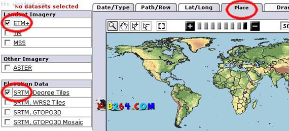
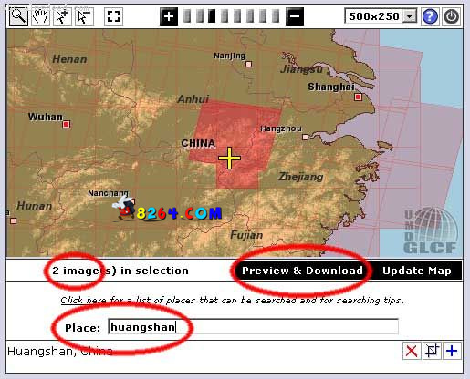
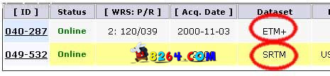
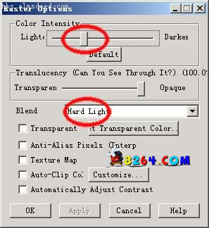
First, the preparation Hardware: A Pentium IV-class computer with no less than 512M of memory and no less than 10G of hard disk space software: * FlashGet 1.65 or higher for downloading huge data files * Global Mapper 6.07 or later for compositing data and generating contour lines * Photoshop 6.0 or higher for editing maps data: * National Basic Geographic Information Http://nfgis.nsdi.gov.cn/nfgis/chinese/c_xz.htm Including China's administrative territory, the main road river * China geographical name data china.name includes tens of thousands of township-level geographical names and coordinates * elevation data SRTM3 global 3D terrain data * satellite photos ETM + remote sensing photos * GPS data, if any, can be synthesized on the map Second, download the data (This tutorial takes "Huangshan" as an example) To Http://glcfapp.umiacs.umd.edu:8080/esdi/search.jsp Download page may also include other data, anyway, pick the largest file size, use FlashGet download right. We thus obtained two data files: P120r039_7p20001103_z50_nn80.tif.gz 115292466 bytes (115M SRTM_u03_n029e118.tif.gz 2230019bytes (2.2M Third, the combined data First open the ETM+ file, that is, "p120r039_7p20001103_z50_nn80.tif.gz", and then press Alt-C to enter the layer adjustment, modify the "Option" of the layer, brighten the brightness to the left, and set the Blend to "Hard Light" .